What’s at Stake
Overview
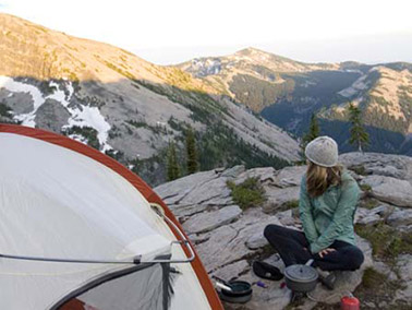
 Wilderness designation is reserved for the rarest of landscapes. Designated in 1964, the Cabinet Mountains Wilderness was among the first 10 areas designated, which makes it not just rare, but remarkably so. If you’ve ever been there, you understand.
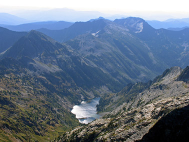
This secluded temperate range is dotted with 85 deep crystal lakes. Its high country of jagged rock cirques gives way to temperate rain forest valleys thickly forested with larch, spruce, fir, cedar and hemlock. The wilderness is home to deer, elk, wolverines, lynx, mountain goats and black bears. It is a stronghold for grizzlies in the lower 48 and harbors the snow that feeds the streams that spawn bull trout.
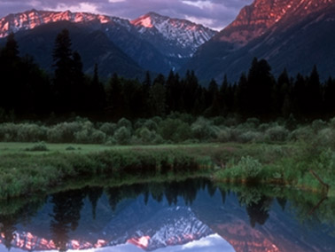
Just downstream is one of the world’s most beautiful and cherished lakes—Lake Pend Oreille. The lake is not only a natural wonder, but also the engine that drives the region’s resort and recreation economy.
In the midst of this pristine and awe-inspiring landscape, a mining corporation plans to introduce deafening machines including primary and secondary rock crushing, rumbling explosives, toxic chemicals from blasting, and a perpetual polluted discharge. Hecla Mining Company callously plans to subject a wilderness place, in which you cannot fire up a chainsaw or ride a bike, to the blunt onslaught of industry.
What’s at stake, then, isn’t a bear, trout, lake, or stream. What’s at stake is the very essence of Wilderness, the very reason places like the Cabinet Mountains Wilderness are protected to begin with. What’s at stake is a price we should all be unwilling to pay.
Water Quality
Water is the lifeblood of the West. Much of the water in the Clark Fork-Pend Oreille Watershed comes from the rain and snow that falls in the Cabinet Mountains. In fact, 90% of the water that comprises Lake Pend Oreille is from the Clark Fork River. Unique in Montana, the Cabinet Mountains are in a temperate rainforest climate and some ranges receive an average of 100 inches of precipitation annually. This water has the distinction of being some of the purest in the continental U.S. In what is a preventable travesty, the Rock Creek Mine would contaminate the water that comes in contact with its proposed industrial operations. Flowing downstream, the polluted water would carry mining toxins and would impact the water quality that small towns all depend upon.
A Perpetual Toxic Discharge:
Wastewater from the Rock Creek Mine would be required to pass though a treatment facility and a diffuser pipe prior to its discharge into the Clark Fork River. Montana Department of Environmental Quality describes the diffuser as “…a perforated pipe running transverse to the flow of the (Clark Fork) river anchored to the bed of the river. The proposed design calls for a diffuser extending the full width of the river (300 feet) in order to provide maximum dilution. Two-inch ports in the pipe would be spaced every ten feet.” Without this diffuser pipe to mix the mine effluent with river water, a concentrated plug of polluted water would enter the river with little mixing. As a result, migrating trout would be more likely to avoid this area of the river with its elevated metals.
Even after the complex water treatment process and dilution with the river via the diffuser, the discharge from the mine would still exceed acute aquatic life standards for copper, cadmium, lead and silver. It would require an additional 300 feet of mixing zone in the river to meet water quality standards for aquatic life. This discharge would also contain additional toxic metals such as mercury, arsenic, manganese, selenium and zinc. The complex system of treatment and discharge though the diffuser would need to be maintained and operated in perpetuity.
The efficiency of the water treatment and the quality of the effluent discharged into the Clark Fork River is based on information provided to Montana DEQ by the mining company and its consulting firm. Montana DEQ determined the limitations of the effluent and simply accepted the assurances from the mining company that the parameters would be met.
A Toxic Mountain of Tailings:
Hecla’s approach to dealing with the mine tailings (waste rock removed from the mine) is fraught with problems. The Rock Creek Mine would produce 100 million tons of tailings, creating a 325-acre mountain of toxic waste rock over a football field high (325 feet). This pile would be unlined and would sit adjacent to Rock Creek and just a quarter mile from the Clark Fork River. Of particular concern is the level of arsenic, a human carcinogen, and other heavy metals in the proposed pile. In fact, the tailings would discharge 20–30 gallons per minute of contaminated water from the bottom of the pile into the aquifer. That’s 43,200 gallons of water a day carrying arsenic, lead, copper, zinc and cadmium into the groundwater that recharges streams, rivers and wells. The U.S. Fish and Wildlife Service recognized the risks to Rock Creek and its bull trout from the tailings when they stated in the 2006 Biological Opinion that “groundwater filtration of metals from the tailings impoundment would risk contamination of Rock Creek.”[/toggle]
Berkley Pit, Underground:
The mining process would create massive underground rooms that would fill with water that has been diverted from the wilderness and surrounding area. During mine production, the water entering these rooms would become contaminated and have to be pumped out to the treatment facility. The post-mining world beneath the wilderness would, however, be vastly different. When the lights have gone out and the machinery has been quieted, the mining company and those that permitted the mine are long gone, and the mine adit (opening) plugged, 2,046 gallons of water will continue to enter the mine every minute of every day. This water will collect forming a subterranean reservoir that will contain 207 million gallons of water, cover 64 acres and be 10 feet deep. It is likely that acid mine drainage and metals leaching will develop in this man-made cavern beneath the wilderness. The polluted water will escape into the wilderness ecosystem via springs and seeps, threatening the East Fork of Bull River, Rock Creek and other tributaries. Stemming the outward flow of contaminated water would be extremely difficult if not impossible.
Vanishing Mountain Lakes:
Subsidence (cave-ins) is an inevitable consequence of underground mining—it may be small and localized or extend over large areas. It may be immediate or delayed for many years. But it can, and commonly does, impact streams, lakes and ponds above underground mining cavities.
“Subsidence can cause the formation of open cracks, fissures or pits, which, if connected either directly or indirectly to surface water (streams, lakes, ponds), may lead to partial or complete loss of water that is drained to lower strata or mine workings. Depletion of water resources in this manner can impact their suitability (quality and quantity) as well as impact aquatic life forms (SME, 1986) and other life, which may depend on surface water systems.” (Excerpted from: Technical Report on Underground Hard-Rock Mining: Subsidence and Hydrologic Environmental Impacts by Steve Blodgett, M.S. and James R. Kuipers, P.E.)
Translation? Even though a mine may be 800 feet below the surface, it can have severe, repercussions on surface water. In the case of the Rock Creek Mine, the ore body sits beneath alpine wilderness lakes and numerous creeks and streams. Cliff Lake sits above what would be the mine cavity and would be one of several alpine wilderness lakes at risk from draining due to the exposure or formation of mine related subsurface cracks and fissures. Cliff Lake also receives 90% of its recharge from groundwater and any “alteration of flow” would starve the lake, causing it to die a slow death.
Wildlife
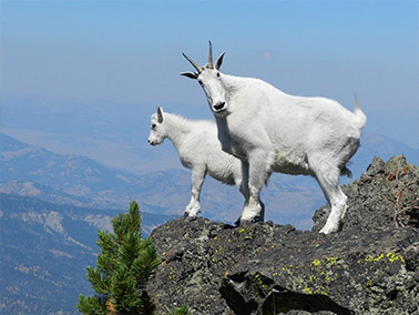
The Cabinet Mountains Wilderness, and national forest lands threatened by the mine, provide important habitat for vast numbers of native wildlife including elk, deer, mountain goats, Harlequin ducks, bighorn sheep, pikas, wolverines, mountain lions, lynx, fishers, and wolves. They also are a refugium for the small, at- risk population of grizzly bears in the Cabinet-Yaak Ecosystem, and provide clean, clear, cold mountain streams for the region’s threatened bull trout.
The mine would create an industrial landscape in this quiet place resulting in disturbance from blasting, mining equipment, truck traffic, and lighting; fragmentation of habitat; and increasing levels of human-caused mortality.
Many species, like grizzly bears, are intolerant of human disturbance. Grizzly bears are reclusive creatures and will not tolerate sharing their habitat with a massive mining operation. The area of activity around the mine would stress bears and impact their habits and travel patterns. Some would be displaced from the area altogether.
Grizzly Bears:
The Cabinet grizzly bear population is already threatened by the loss and degradation of habitat critical for its survival in the region. The Rock Creek Mine will cause the Cabinet grizzly population to lose over 7,000 acres of its historic range, a loss that will not be replaced by the mine’s mitigation plan as proposed by the U.S. Fish and Wildlife Service. The mitigation plan calls for the 7,044 acres of lost habitat to be offset by the protection of 2,450 acres, where available, from future development. How will trading 7,000 contiguous acres for 2,450 fragmented acres, that if undeveloped would already be available to bears, constititute a win for the bear?
Another mitigation is the funding of a Montana Fish, Wildlife and Parks grizzly bear conflict specialist. In the first test of its effectiveness, this position failed to protect a bear that was poached by a local business owner.
On top of the already-growing influx of new residents that is creating pressure on existing, inadquate infrastructure, some 3,000 additional residents will migrate to the region in search of mining jobs. This continuing and rapid influx of humanity will carve up more bear habitat, resulting in more people encroaching into the forests to hunt, cut firewood, and recreate. All of this elevates the risk of bear deaths. Even the U.S. Fish and Wildlife Service acknowledges the risks stating, “the potential for poaching could increase with the influx of workers with diverse social, cultural and economic backgrounds, many of whom may be unfamiliar with or lack interest in wildlife conservation.” (2006 Biological Opinion)
Bull Trout:
Bull Trout require clean, cold water, free of fine sediment for all life stages and activities, especially spawning and rearing. The introduction of sediment and silt into Rock Creek from road building associated with the mine’s construction could impact bull trout by impeding reproduction and damaging water quality. Fine sediment introduced into spawning and rearing habitat increases the mortality of eggs, embryos, and juvenile fish. The Rock Creek Mine is expected to introduce hundreds of tons of sediment during construction (400 to 1,400 tons per year.) The USFWS has predicted that “any significant increase in fine sediment levels in bull trout spawning areas [in Rock Creek] will most likely have negative effects on productivity of bull trout.” The mine’s construction could very well wipe out bull trout in Rock Creek.
Bull trout could also be impacted by the introduction of metals into Rock Creek. Bull trout can detect even minute concentrations of metals and will actively avoid areas were they are elevated. Trout attempting to swim up Rock Creek from the Clark Fork River might avoid Rock Creek altogether if they detect elevated metals.
Sensitive & Threatened Wildlife:
Other fish and wildlife species in the project area that are of special concern or have a protected status due to declining numbers include westslope cutthroat trout, Harlequin ducks, lynx, wolverines, and mountain goats.
Harlequin ducks, waterfowl that require clean, fast flowing mountain streams for breeding, are declining in number throughout their range. Very sensitive to human disturbance, they winter of the Pacific Coast and breed in relatively few streams in the intermountain West. Each spring, small numbers migrate from the West coast to Rock Creek to nest. Vulnerable to human activities, sediment from road construction could eliminate the duck’s aquatic insect food base while industrial noise and lighting from the mine’s mill site could cause breeding females to completely abandon the area.
Westslope Cutthroat Trout would be subject to the same impacts as Bull Trout including both road-generated sediment and heavy metals entering Rock Creek and the Clark Fork River.
Lynx are a threatened species. The mine would result in the loss of lynx habitat, including habitat for denning, and could result in decreased reproductive success and increased mortality risks. Likewise, wolverines also would be impacted by increased mortality resulting from the mine’s disturbance.
The mountain goats that inhabit many of the rocky cliffs and outcroppings in the Cabinet Mountains thrive on the solitude that these high mountain places provide. Intolerant of human disturbance, stress caused by the mine is predicted to reduce the health and reproductive success of the area’s goat herd. Habitat loss, hunting, and poaching could lead to direct mortality of those goats not driven out of the area.
The mine would affect all of these species by transforming a quiet and rural, forested landscape into an industrial zone accompanied by a high volume of traffic and constant industrial noise and lighting. At the same time, the water quality of Rock Creek would be severely degraded. The area would no longer be a suitable home for much of the area’s fish and wildlife.
Lake Pend Oreille
Lake Pend Oreille is truly unique with outstanding recreational and aesthetic properties, and has been deemed a “Health and Recreation Place” by Idaho’s Legislature. It is 128 square miles and has 43 miles of shoreline. At 1,158 feet deep, it is among the deepest lakes in the country. It has endured ice ages and floods. The question is, Can Lake Pend Oreille survive the Rock Creek mine?
The Slow Death:
The Rock Creek mine would discharge polluted wastewater into the Clark Fork River every day. One estimate is up to 3 million gallons per day. This discharge would contain nutrient pollution (nitrogen and phosphorus) and heavy metals, including arsenic, lead, copper, zinc and mercury. The discharge would flow 20 miles downstream into Idaho, soon entering Lake Pend Oreille. Other mine discharges would include seepage of metals from the bottom of an unlined mine tailings pile that would seep into groundwater feeding the Clark Fork River. And the mine’s underground cavity would create a source of perpetual pollution that would escape the mine through fissures and cracks finding its way downstream. In other words, the Rock Creek Mine turns Lake Pend Oreille’s source of pure, clean water into a source of perpetual pollution.
The Toxic Plume:
Any number of events could lead to unexpected and uncontrolled releases of polluted wastewater from the mine. Large storm events would allow untreated wastewater to flow into McKay Creek, Rock Creek, and the Clark Fork River. Ten and 100-year storm events (storms of the size that would be expected to occur on average every 10 or 100 years) are not uncommon in the Cabinet Mountains, where an average of 100” of precipitation is received each year. During events of even a 10-year size, the mine is authorized to discharge untreated water from holding ponds into local streams.
Failure of the treatment systems or ruptures in the tailings slurry line would also lead to a release of untreated water or tailings. Tailings line breaks and mishaps have occurred at the Troy Mine resulting in raw tailings entering local creeks.
The unthinkable—a failure of the tailings impoundment—would result in a catastrophic event in which hundreds of thousands of tons of mine tailings could be dumped into the Clark Fork River.
Community
 Ask anyone who lives in North Idaho or northwestern Montana why they live here and you’ll hear the same three words—quality of life. That quality comes from the surrounding beauty to be sure, but it also comes from the lack of traffic, the safety of neighborhoods, and the peace and quiet. The Rock Creek Mine will surely diminish our quality of life. Here’s how.
Hand-Me-Down Pollution:
Many of the negative impacts from the Rock Creek mine will be both permanent and perpetual. Area residents will be forced to live with the mine’s legacy of pollution, and Montana and Idaho taxpayers with the costs of cleaning it up. An unlined tailings pile will forever leak into groundwater, and be so large that it will literally alter the topography of the region, creating a new mountain on the landscape. The mine’s discharge of polluted effluent into the Clark Fork River every day will require treatment for generations. The water treatment facility, pipelines, and diffusers will likely need to be maintained for centuries. Waste rock with acid-generating and metal-leaching potential from the evaluation adit would be “end dumped” adjacent to the Cabinet Mountains Wilderness and the west fork of Rock Creek, creating yet another source of contamination. Around-the-clock diligence would be required to monitor and attempt to treat the multitude of long-term impacts from the Rock Creek Mine.
Population Explosion:
The communities in the region of the proposed Rock Creek Mine would grow by 50–75% in a matter of a few months. The Montana towns of Trout Creek, Noxon, and Heron would bear the brunt of the adverse social impacts from the Rock Creek mine, producing a classic “boom and bust” situation for these small communities. Due to a lack of available temporary housing for the transient workforce, many will be forced to live in sub-standard housing including sites that are not suited for residential use. The federal agencies that permitted the Rock Creek Mine acknowledge that medical services, police, emergency services, and schools will have difficulty responding to the increased demand and may be forced to “tough it out.” These same agencies also admit that limited law enforcement resources would be in demand because many of the employees would have few, if any, ties to the community and limited access to social opportunities.
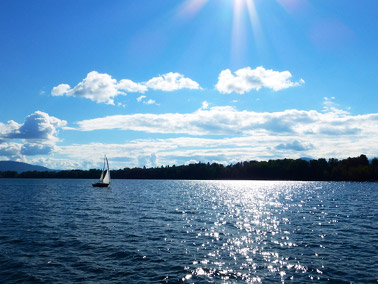
Recreation Economy
 Lake Pend Oreille isn’t only a body of water. And the Cabinet Mountains Wilderness isn’t just a patch of forest. They’re magnets that attract visitors, residents and dollars. But how much draw will a polluted lake have? Can a wilderness diminished by the noise of industry attract hikers and wildlife watchers? If the Rock Creek Mine is permitted, the future of the region as a recreation destination will be jeopardized.
Businesses Depend on Tourism:
The region surrounding the proposed Rock Creek mine is thriving on an economy based on recreational tourism including sport fishing, hiking, hunting and boating. The area’s economy has also been boosted by the influx of amenity immigrants who have made the region home because of the quality of life it offers. Following the lure of a pristine environment, the new members of the communities have built homes, employing the skilled crafts people from Sandpoint, Idaho to Thompson Falls, Montana. The federal permitting agencies acknowledge that the Rock Creek mine would bring to an end the recent surge in amenity immigrants and likely chase from the region many of those who moved here because of quality of life.